By: Jayden Pan, Content Strategist at 1UP Youth City Builders

The waterfront of a city is arguably one of its most defining and vibrant features, serving not only as a hub for recreation but also as a landmark symbolizing the connection between the urban environment and the natural landscape. What captivated my attention was a project close to home. With my interest in urban planning and architecture, I was fascinated by the transformative power of innovative planning happening just on the outskirts of Toronto. This project often goes unnoticed to residents of Toronto, however, the incredible feat of industrial design, urban planning, and innovation in revitalizing Toronto’s waterfront stands as a beautiful example for other youth like me. It demonstrates the power of thoughtful urban design in addressing climate change and urbanization challenges, encouraging us to become informed and active participants in shaping the future of our communities.
How exactly will the Port Lands revitalization transform our city, and what can we learn from this innovative project?
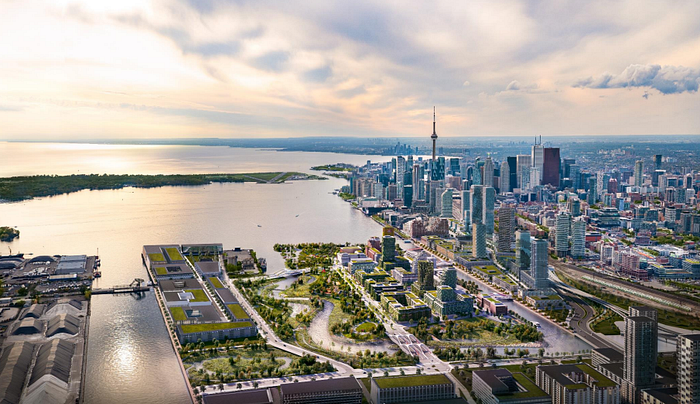
The Port land’s, located southeast of downtown Toronto, has historically been an industrial area, which was part of a project that saw the filling of Lake Ontario back in the early 20th century. Today, the lands continue to be used for industrial and port functions, but there are large amounts of vacant and underutilized land, holding large potential for urban development and aiding the worsening housing crisis.
The vision for the Port Lands revitalization project is ambitious, turning it into a dynamic, inclusive mixed-use community, with housing at all levels of affordability combined with supportive community infrastructure while focusing on sustainability. The project is a collaboration between The City of Toronto, together with CreateTO and Waterfront Toronto, with a focus on creating a world-class waterfront district.
Key Components of the Revitalization
Flood Protection:

One of the most critical aspects of the Port Lands project is flood protection. The area is prone to flooding due to its low-lying topography and proximity to the Don River. As sea levels rise and extreme weather events become more common, significant measures must be implemented to safeguard not only the Port Lands but also the rest of Toronto. In 1954, Hurricane Hazel already devastated Toronto, leaving thousands homeless and causing the deaths of 81 people. A hurricane of this magnitude today could result in hundreds of millions of dollars in damage.
The Don Mouth Naturalization and Port Lands Flood Protection Project aims to reconfigure the existing mouth of the Don River, creating a healthier, naturalized river outlet to the Toronto inner harbor and Lake Ontario. This project will handle large volumes of water and mitigate flood risks to 240 hectares (593 acres) of land, unlocking this area for development and new housing supply on Villiers Island. By reshaping the Don River, this project unlocks new land that can be made available to be used for housing development, businesses as well as new parks and green spaces enhancing the downtown waterfront while boosting Toronto’s resilience to extreme weather events and flooding.
New Parks and Public Spaces:
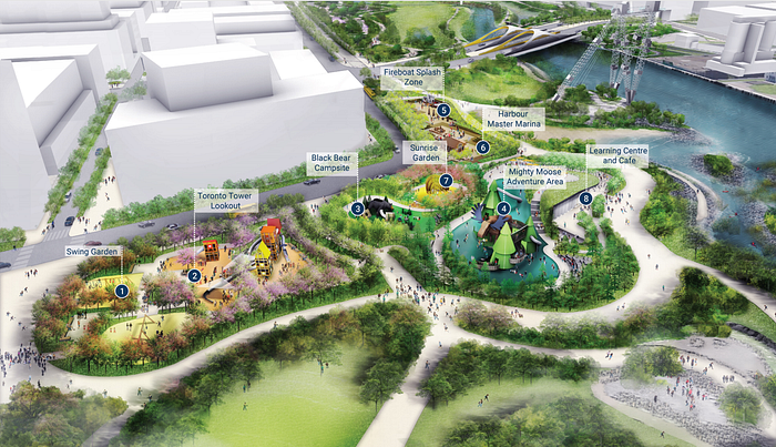
Central to the revitalization efforts is the creation of new parks and public spaces, with Don River Park at the forefront, offering green spaces, walking and biking trails, and recreational facilities for residents and visitors. The Flood Protection Project added three kilometers of waterfront access and more than 11 hectares (100 acres) of new parkland. To date, more than 43 hectares (106 acres) of parks and public spaces have been added to waterfront neighborhoods, ensuring that residents have places to unwind, be active, and connect with nature.
As part of this park system, a Destination Playground will be created, a major free attraction featuring cutting-edge playground design and nature play, which will be one of a handful of such playgrounds in the world and the first in Canada. These new parks will deliver a world-class amenity, expected to attract over a million visitors a year, and provide children with opportunities for challenging play that offers significant developmental benefits, enhancing the quality of life for Toronto’s residents and attracting visitors from around the world.
Mixed-Use Development:
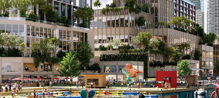
The revitalization plan includes a diverse range of residential, commercial, and cultural developments, intending to create a vibrant, 24/7 community where people can live, work, and play. This includes affordable housing options, office spaces, and retail establishments, all designed to foster a dynamic urban environment. The Villiers Island precinct plan initially contemplated about 4,800 units, including 1,000 affordable units, but its partners are exploring the potential for increased density in the area to boost housing supply while adhering to the guiding principles of the Precinct Plan. These principles emphasize animating and activating the water’s edges, creating a network of open spaces and waterside parks, reinforcing the Island as a regional destination and gateway to the waterfront, and celebrating the area’s industrial heritage through conservation.
The plan prioritizes pedestrian, cycling, and transit infrastructure, ensuring a connected and accessible community. It aims to develop a diverse, mixed-use, and inclusive community with employment opportunities and a variety of affordable and family-oriented housing options. Additionally, the plan focuses on providing a variety of building forms to create a distinct skyline, developing a climate-positive urban community, and ensuring the viability of the supporting infrastructure, ultimately creating a thriving, inclusive community that balances residential, commercial, and recreational needs.
Sustainable Design:
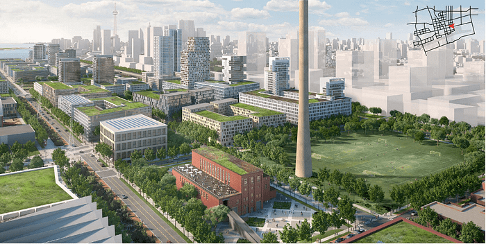
Sustainability is at the core of the Port Lands project, with redevelopment plans incorporating green building practices, energy-efficient infrastructure, and innovative water management systems. The aim is to create a model for sustainable urban development that can serve as a blueprint for other cities worldwide. Villiers Island, of the Port Lands, will be Canada’s first climate-positive neighborhood, meaning it will produce more clean energy than it uses and have greenhouse gas (GHG) emissions close to zero, while also catalyzing GHG emission reductions in neighboring communities, showcasing the nation’s commitment to climate change mitigation with features such as low-carbon buildings, solar energy storage, and deep geothermal district energy setting a new standard for eco-friendly urban development.
Enhanced Connectivity:
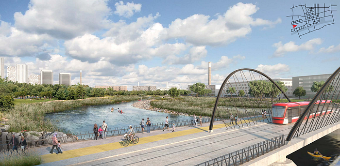
Improving transportation and connectivity is another key goal of the revitalization plan. This includes enhanced public transit options, new bike lanes, and pedestrian-friendly streetscapes. The aim is to reduce reliance on cars, promote active transportation, and seamlessly connect the Port Lands with the rest of Toronto. Streets like Cherry Street and Commissioners Street are being widened and realigned to accommodate dedicated transit and cycling lanes, pedestrian pathways, and multi-use trails. Villiers Island and other waterfront neighborhoods could also be served by new modes of transit, with collaboration underway between government partners, CreateTO, and the Toronto Transit Commission on the approval of Waterfront East Light Rail Transit (LRT).
Ensuring that any new transit is effectively planned and well integrated into the area is crucial, as new neighborhoods can only fulfill their potential if residents and workers can easily come and go. A growing number of employers are interested in moving offices and jobs to the waterfront, with many already having done so. For many of these employers, an LRT is a critical consideration, and efforts are being made to deliver one quickly. The improvement of transportation and connectivity ensures the successful integration and development of the Port Lands as a dynamic and accessible urban hub.
Impact on Toronto:
The revitalization of the Port Lands is expected to have a profound impact on Toronto in several ways:
- Economic Growth: The project is set to stimulate economic activity by attracting businesses, creating jobs, and boosting tourism. In particular, Villiers Island will achieve 340 to 415 residents and jobs combined per hectare.
- Environmental Benefits: The focus on sustainability and flood protection will enhance the environmental resilience of the area, creating a healthier and more sustainable urban ecosystem.
- Social and Cultural Vibrancy: By creating new public spaces, and mixed-use developments, the Port Lands will become a hub of social and cultural activity, enriching the community’s quality of life.
- Urban Innovation: The Port Lands project represents a pioneering approach to urban development, integrating advanced design principles and technologies that can inspire similar initiatives globally.
The revitalization of Toronto’s waterfront is more than just a transformative city project; it’s a personal inspiration for me and a reflection of the city’s commitment to sustainable and innovative urban development. As someone deeply interested in urban planning and architecture, I am captivated by how this project reimagines a once-industrial area into a vibrant, mixed-use community that connects the city with its natural surroundings. It stands as a powerful example for youth like me, showing the potential of thoughtful urban design in tackling the challenges of climate change and urbanization. This initiative is not only reshaping Toronto’s landscape, but also setting a global standard for waterfront redevelopment, reminding us all the impact we can have in shaping the future of our communities.
